
Comprehensive Wastewater Plan (CWMP)
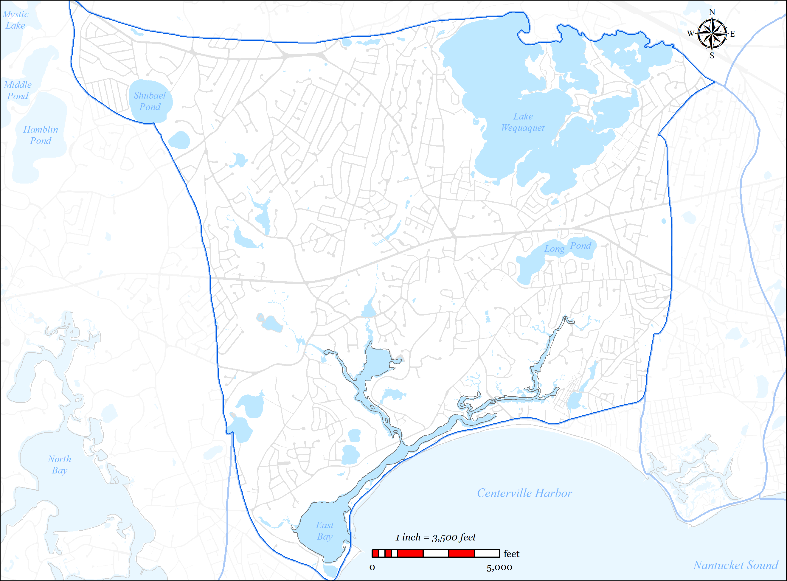
The Centerville River Embayment System is a complex embayment system located in the southern, central portion of the Town of Barnstable. The embayment has a lone inlet which connects Centerville Harbor to Nantucket Sound with a number of sub-embayments (East Bay, Centerville River, Bumps River, Scudder Bay, and Centerville River marshes). For a detailed description of the embayment system, refer to the 2006 MEP Report for the Centerville River Embayment (Appendix Y).
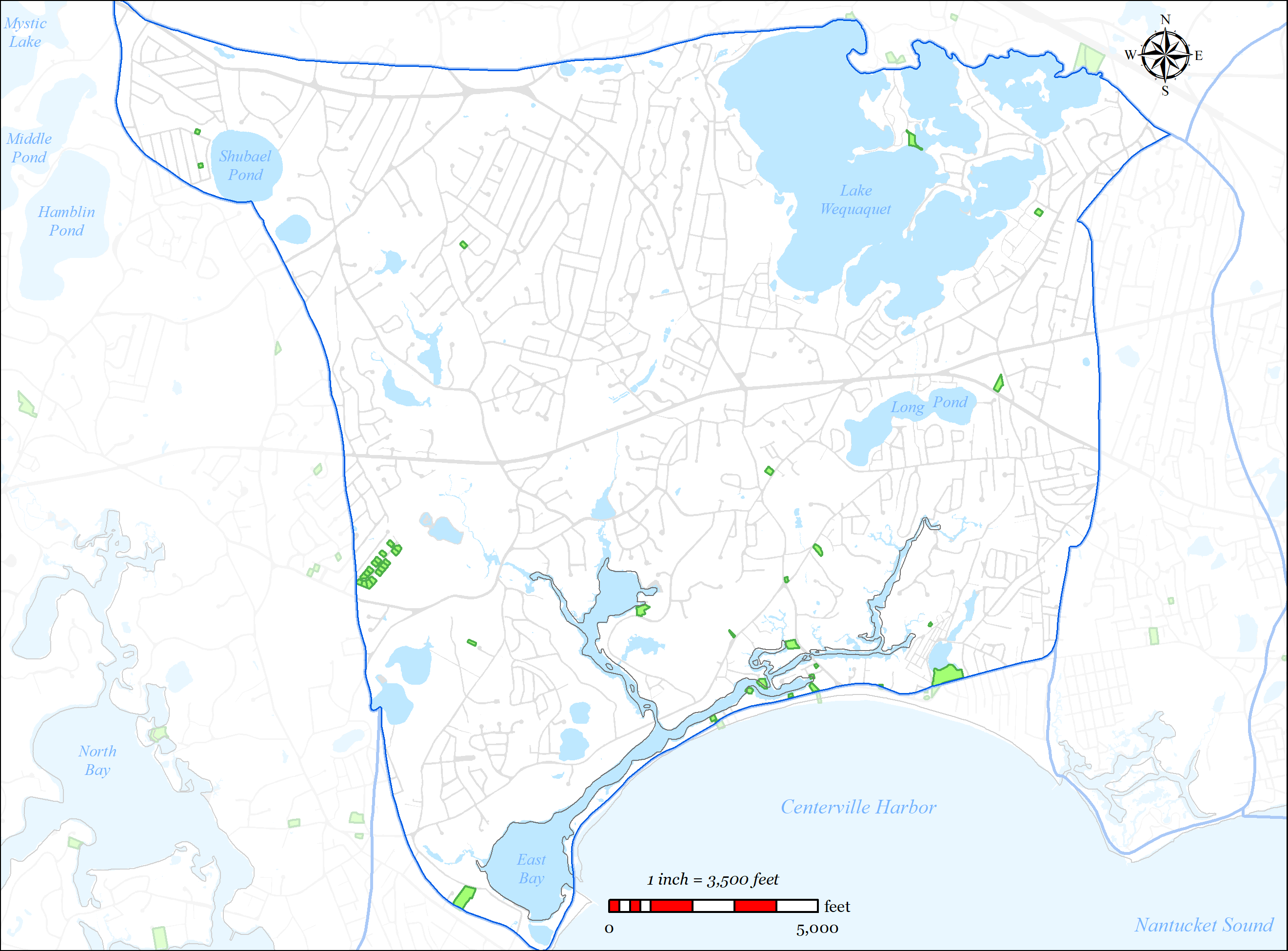
The source water for the Centerville River Embayment System is the Centerville River Watershed. The Centerville River Watershed is approximately 6,739 acres and is located entirely within the Town of Barnstable (See Figure 5-26). Within the watershed there are 39 identified surface waters including 14 named freshwater ponds (Wequaquet Lake, Bearses Pond, Shallow Pond, Long Pond, Red Lily Pond, Lake Elizabeth, Filenes Pond, Lumbert Pond, West Pond, North Pond, Skunknet Pond, Michah Pond, Joshua’s Pond, Shubael Pond) and 4 significant freshwater stream outlets (Skunknett River, Bumps River, Long Pond Stream, Lake Elizabeth). COMM Water District operates 6 drinking water wells that are located within the watershed. The Town operates two smaller wastewater treatments facilities within the Centerville River Watershed; the Marstons Mills School Treatment Plant (permitted for 42,900 GPD) and the Red Lily Pond shared septic system.
The Town of Barnstable’s wastewater plan has been designed to address multiple needs areas within the Centerville River Watershed, including nutrient removal, pond protection, flood zone considerations, and economic development, via sewer expansion into Centerville River Watershed.
5.2.3.1 SUMMARY OF NEEDS
The Town of Barnstable’s wastewater plan has been designed to address multiple needs areas within the Centerville River Watershed, including nutrient removal, pond protection, water supply protection, flood zone considerations, and economic development, via sewer expansion within the Centerville River Watershed.
-
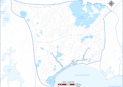
Figure 5-26: Centerville River Watershed
-
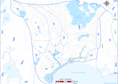
Figure 5-27: MEP-modeled Existing Septic Removal in Centerville River Watershed
-
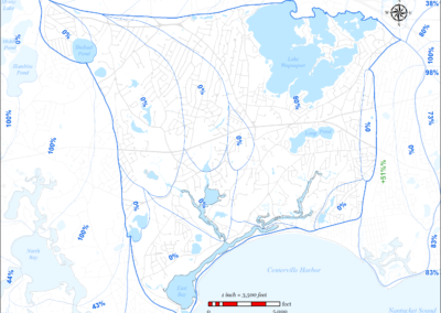
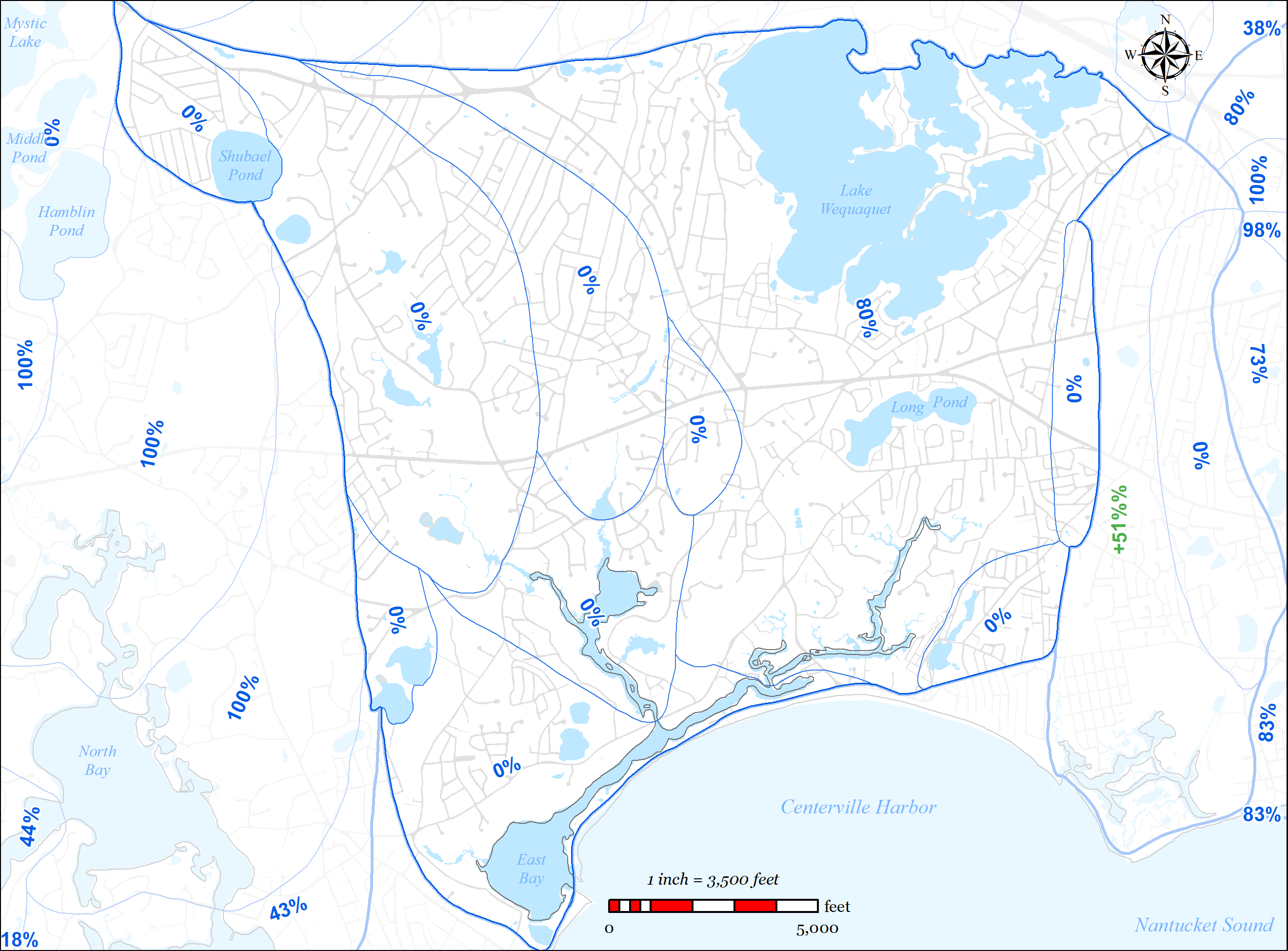
Figure 5-28: MEP-modeled Future Septic Removal in Centerville River Watershed
-
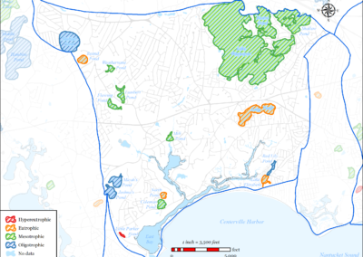
Figure 5-29: Impaired Ponds in Centerville River Watershed
-
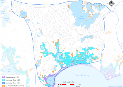
Figure 5-30: FEMA Flood Zones (2014) in Centerville River Watershed
-
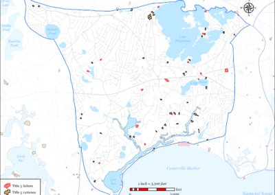
Figure 5-31: Parcels with Title 5 Septic Failures and Variances in Centerville River Watershed
-
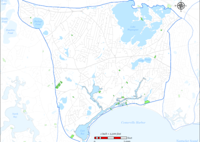
Figure 5-32: Parcels with I/A Septic Systems in Centerville River Watershed
-
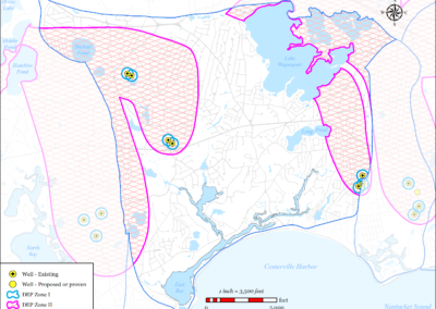
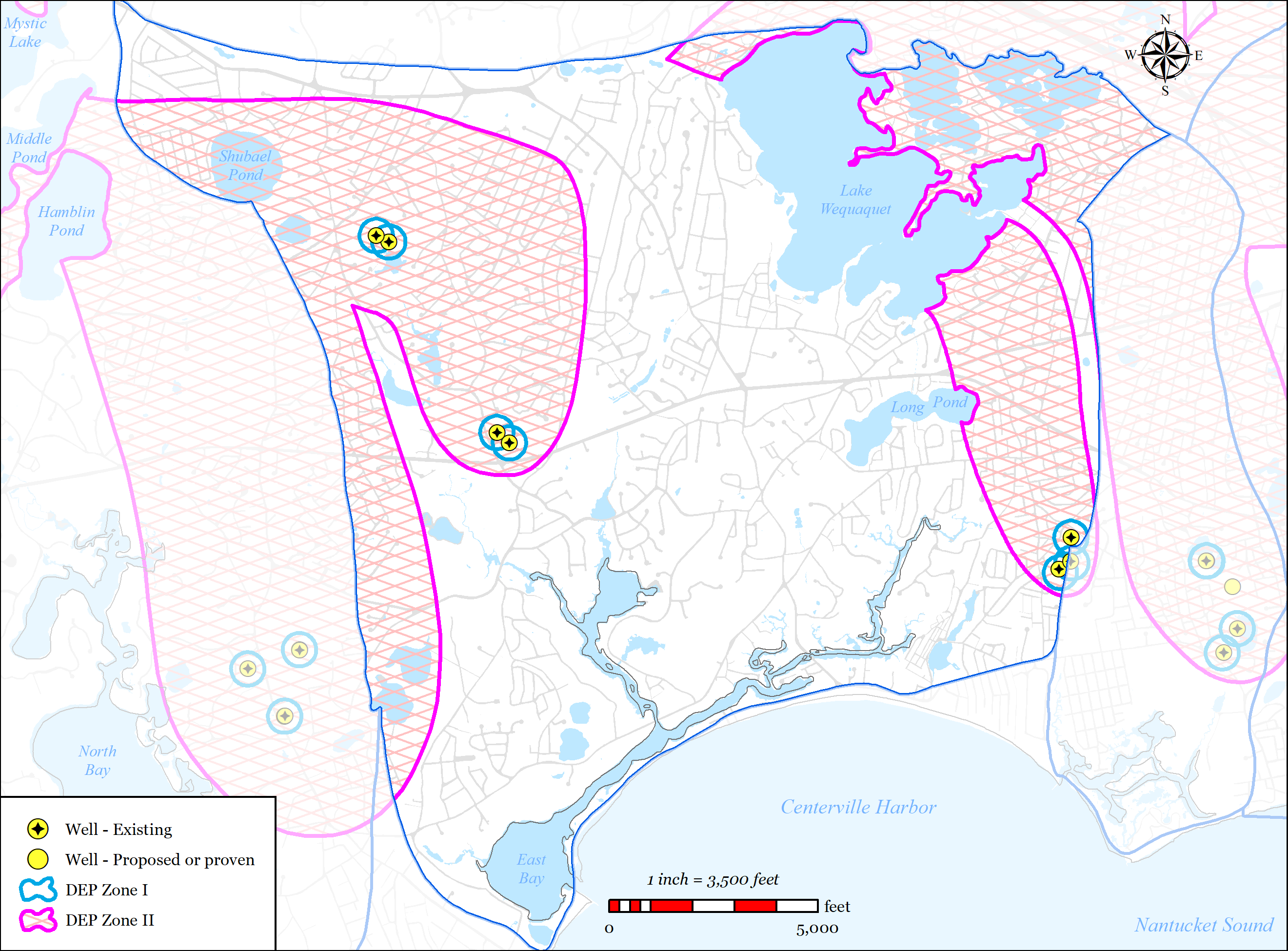
Figure 5-33: Public Water Supply Wells in Centerville River Watershed
-
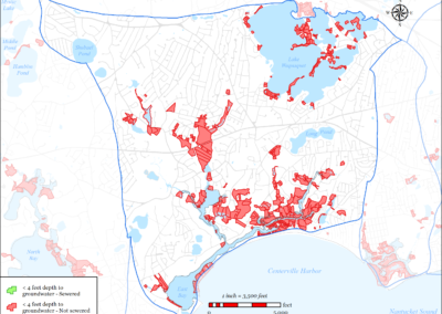
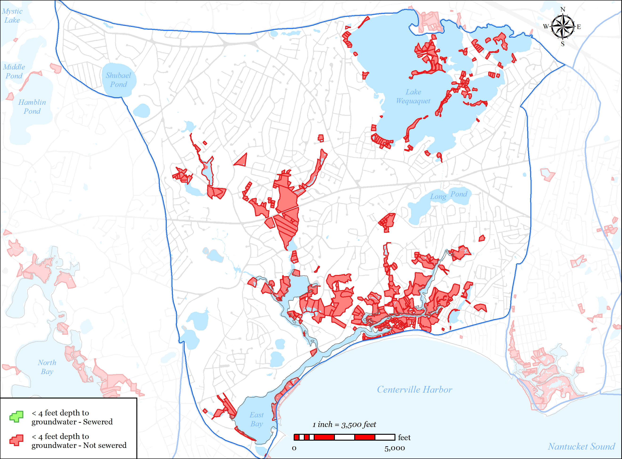
Figure 5-34: Parcels with Less than 4 feet Depth to Groundwater in Watershed
-
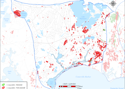
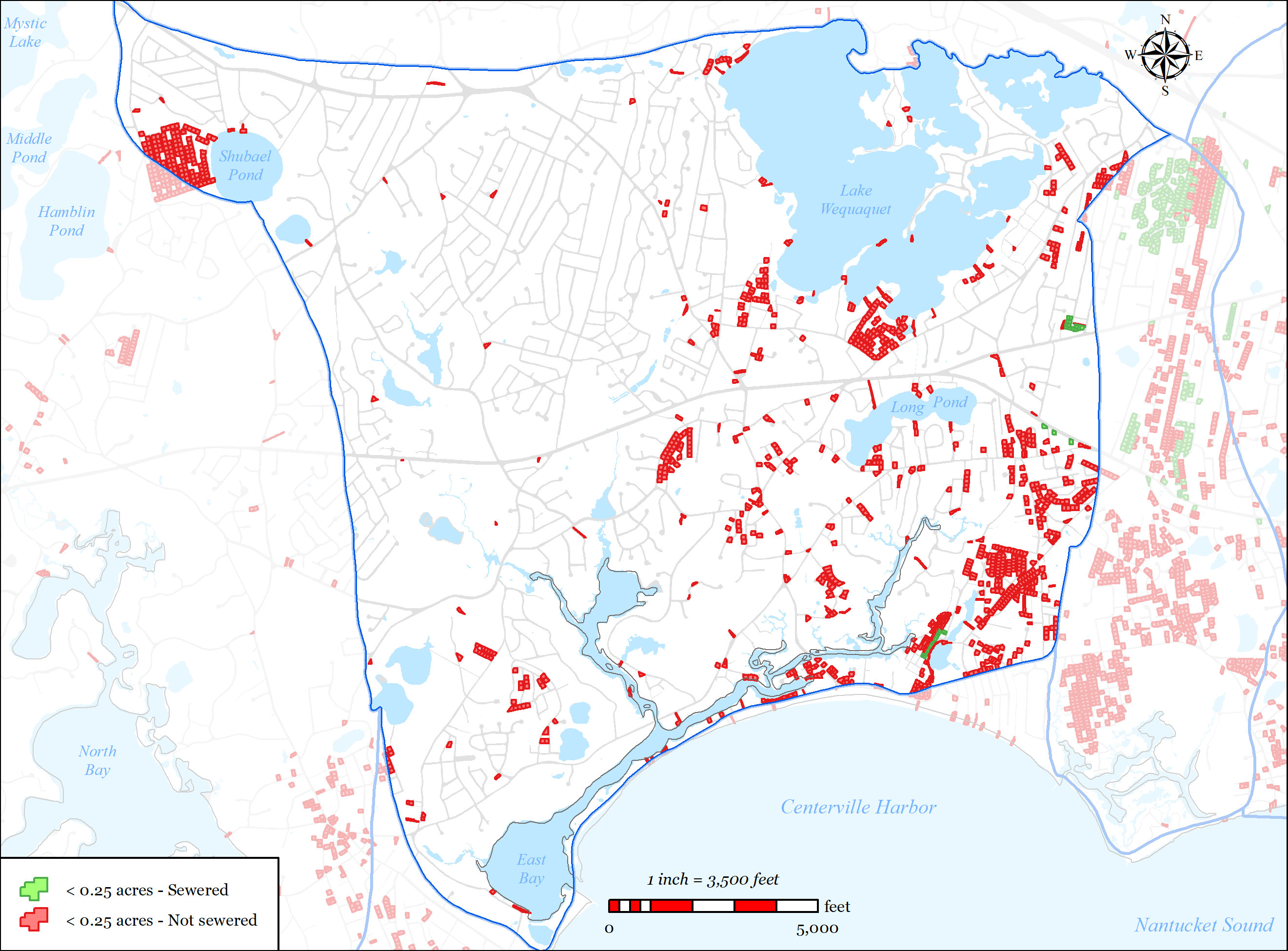
Figure 5-35: Parcels with Less than 0.25 acres in Centerville River Watershed
-
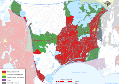
Figure 5-36: Needs Areas in Centerville River Watershed
-
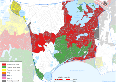
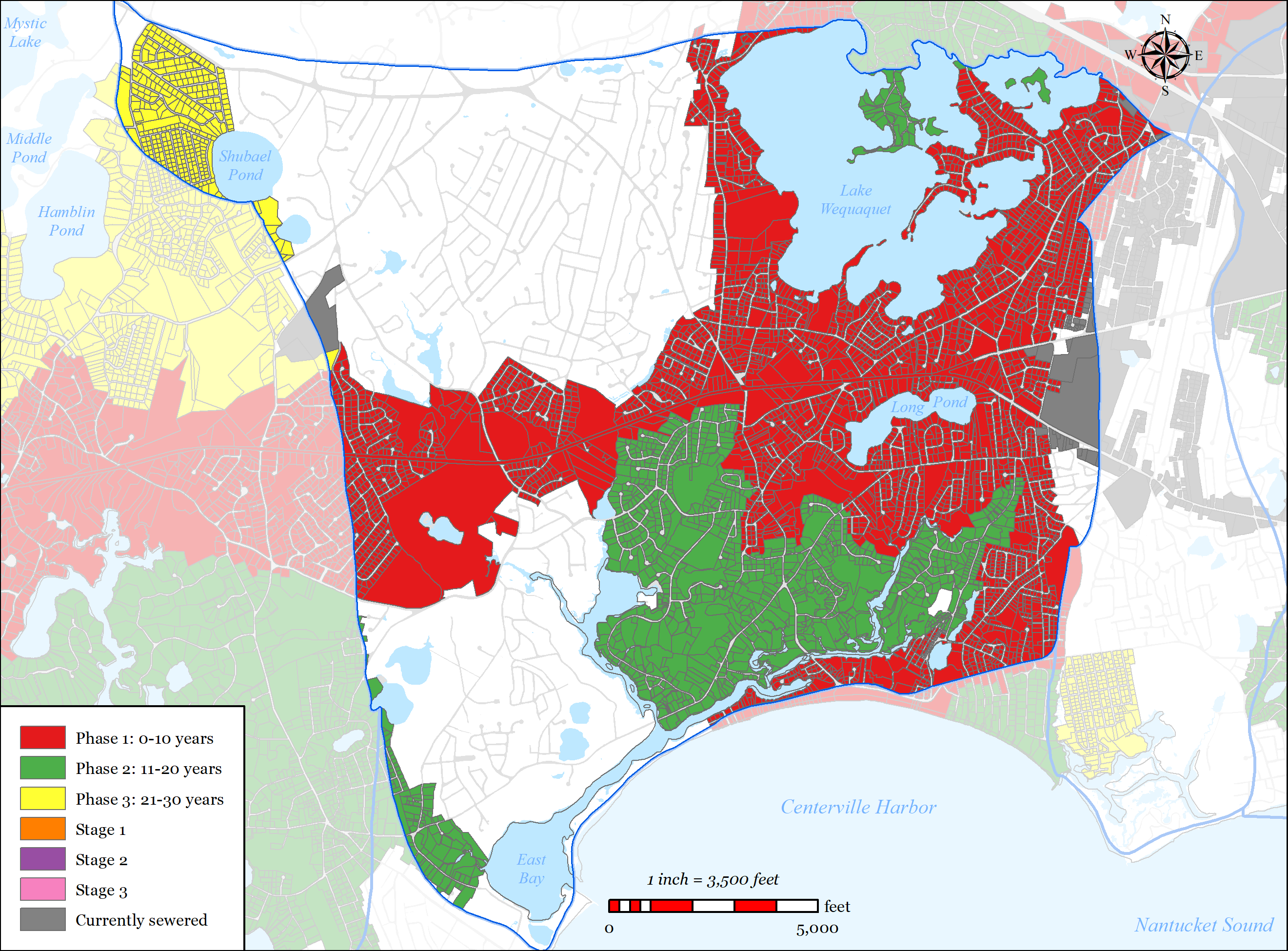
Figure 5-37: Sewer Expansion Plan in Centerville River Watershed


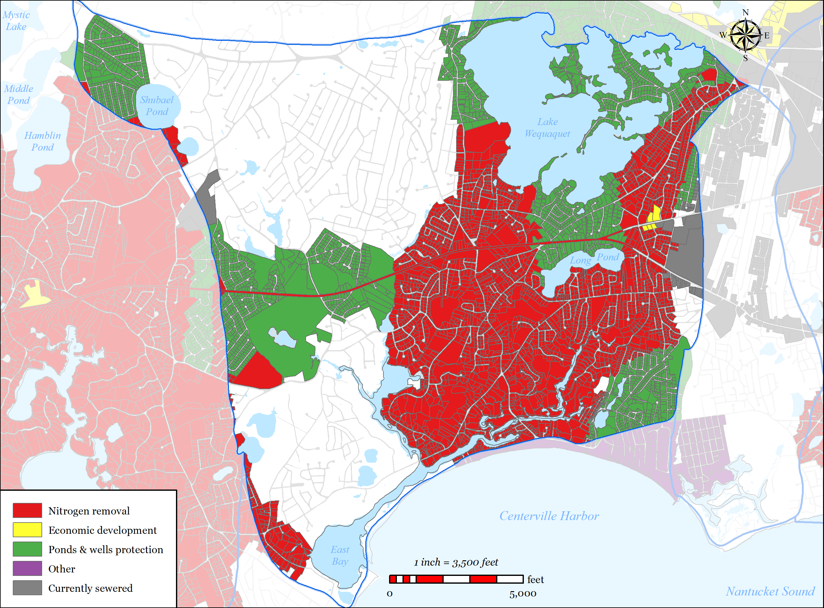
5.2.3.1.1 Nutrient Removal
The 2006 MEP technical report for the Centerville River system indicates that the system exceeds its critical threshold for nitrogen, resulting in impaired water quality. Based upon the findings of the MEP technical report, a TMDL for nitrogen has been developed and approved.
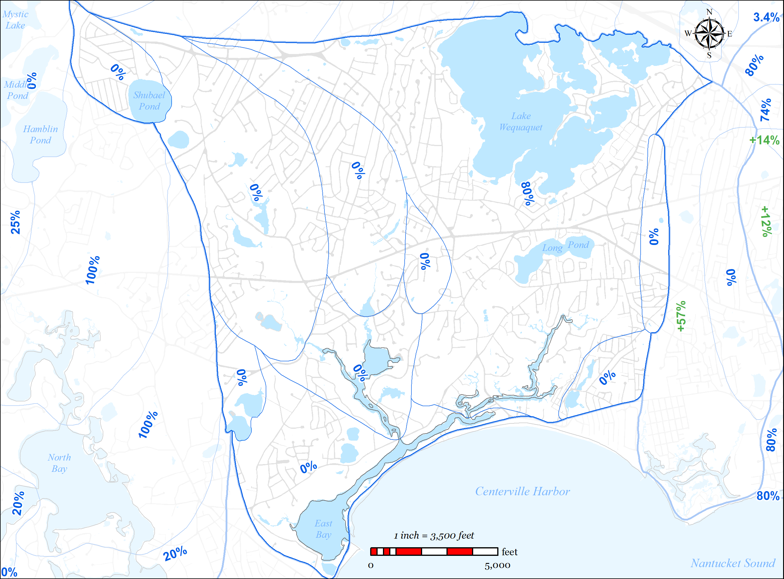
The Town’s wastewater plan has been designed to exceed the septic load removals suggested in the 2006 MEP Report’s threshold loading scenarios. Those scenarios modeled an 80% reduction
in septic load (36.75 kg/day-N) within the Centerville River East sub-embayment and no reduction in septic load in the other sub-embayments within the watershed. This corresponds to a 34% overall average watershed septic reduction target.
The Town’s wastewater plan includes removal of 86% of the total un-attenuated septic load within the Centerville River East sub-embayment via proposed sewer connections (2,056 properties within the sub-embayment). As can be seen in Figure 5-37, the majority of the sewer expansion within the sub-embayment is planned for Phase 1, which will remove 65% of the total un-attenuated septic load within the sub-embayment.
The proposed additional sewer expansion within the other sub-embayments only further contributes to the overall septic load removal within the watershed as a whole. The plan will result in a total un-attenuated septic load reduction across the watershed of 54% (71.6 kg/day N). Phase 1 of the plan will result in a total un-attenuated septic load reduction within the watershed of 40% (52.7 kg/day N).
Nitrogen removal data reported above is from the Town of Barnstable’s wastewater planning GIS tool and reflects calculated existing, un-attenuated nitrogen loads based upon existing water use data.
5.2.3.1.2 Wastewater Needs (Other Needs)
Title 5 Issues
Integral to the planning process was the Town’s development of a wastewater planning GIS tool which allowed Town staff to spatially map traditional Title 5 concerns such as small lot size, depth to groundwater, existing septic variances, existing known failed septic systems, and systems within Zone IIs. Parcels with area less than 0.25 acres were flagged because of they were considered difficult to site a traditional septic system, likely to need septic variances, and increased density leading to increased nutrient loading. Parcels with an average depth of groundwater of less than four feet were flagged as likely to require raised systems which are costly and less desirable for community aesthetics. Existing septic variances and existing known failed septic systems were also mapped.
The tool allows the Town to overlay these layers to identify the “hot-spots” for traditional sewering solutions. These areas were then incorporated into the plan where practical. Many of these “hot-spots” overlaid other needs such as nutrients and pond protection. The Plan for the Centerville River Watershed significantly address traditional Title 5 concerns as shown in the data presented below which was calculated using the Town’s wastewater planning GIS tool (this data does not account for attenuated nitrogen data):
- Total parcels within the Centerville River Watershed = 7998
- Parcels with total area less than 0.25 acres = 1,199
o 1,019 (85%) will be addressed with a traditional solution in the Plan Parcels with average depth to groundwater less than four feet = 391
o 336 (86%) will be addressed with a traditional solution in the Plan Parcels with septic system variances = 50
o 42 (84%) will be addressed with a traditional solution in the Plan Parcels with known failed septic systems = 14
o 10 (71%) will be addressed with a traditional solution in the Plan Parcels located within a Zone II = 3,333
o 1,700 (51%) will be addressed with a traditional solution in the Plan
Flood Zones
Low lying areas to the south of the Centerville River and on the south side of Craigville Beach Road have been identified as needs areas for sewer expansion due to being within the 100 year floodplain and/or the velocity zone, and generally having shallow depth to groundwater. As a result of these conditions, traditional Title 5 septic systems are difficult and costly to site in these areas. It should be noted that the parcels on the south side of Craigville Beach Road are generally outside of the Centerville River Watershed, but have been included in this section due to proximity to the watershed.
- Total parcels within the Centerville River Watershed = 7,998
- Parcels within 100 year flood plain and/or velocity zone = 822 (10%)
o 652 (79%) will be addressed with a traditional solution in the Plan
o This data does not include the aforementioned parcels on the south side of
Craigville Beach Road that are outside of the watershed.
Contaminants of Emerging Concern (CECs)
Contaminants of emerging concern (CECs) are increasingly being detected in surface water.
(CECs) are made up of three general groups, endocrine disrupting compounds, pharmaceuticals, and personal care products. These compounds and potential contaminants are not currently regulated by the federal government because their toxicity is not well understood. Collecting wastewater with sewers and treating at a centralized treatment location allows the opportunity to treat wastewater for CECs as they are better understood and future treatment technologies are developed.
5.2.3.1.3 Pond Protection
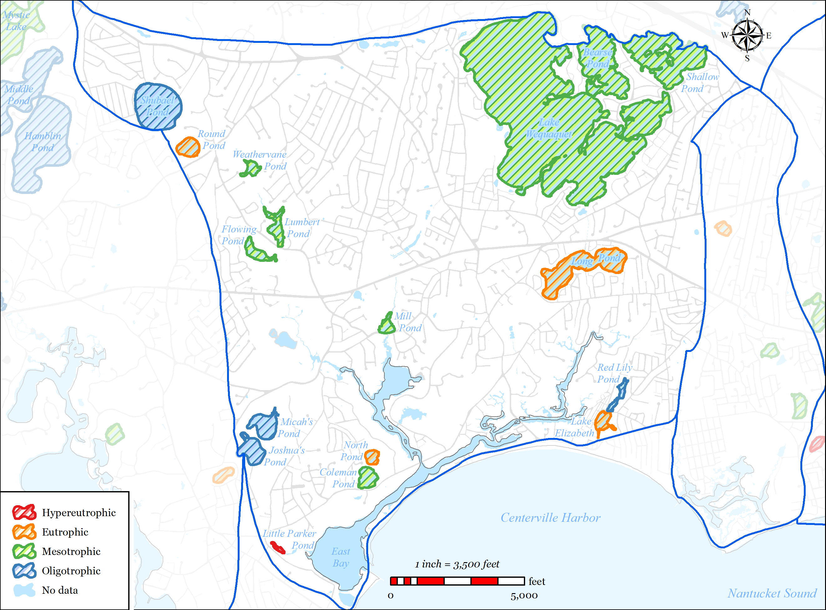
The Town’s wastewater planning has included detailed studies of ponds 3 acres or larger throughout the Town. Through those studies, there is extensive water data for 16 ponds in the Centerville River Watershed. Pond classification of these ponds is shown in Table 5-8 and Table 5-9.
Table 5-8: Centerville River Watershed Pond classification 2009
|
Ultra-Shallow 0 to 2.1m |
Shallow 2.1 to 8.6m |
Deep >8.6m |
|
|
Oligotrophic |
Red Lily Pond |
Joshua’s Pond |
Micah’s Pond Shubael Pond |
|
Mesotrophic |
Lumbert Pond |
Coleman Pond Shallow Pond Bearse Pond |
Lake Wequaquet |
|
Eutrophic |
Round Pond Long Pond |
||
|
Hypereutrophic |
Little Parker |
Table 5-9: Centerville River Watershed Pond classification 2017
|
Ultra-Shallow 0 to 2.1m |
Shallow 2.1 to 8.6m |
Deep >8.6m |
|
|
Oligotrophic |
|||
|
Mesotrophic |
Flowing Pond Mill (Filenes) Pond Weathervane Pond |
Coleman Pond |
|
|
Eutrophic |
North Pond |
||
|
Hypereutrophic |
Three ponds within the watershed have been identified as impaired: North Pond, Long Pond, and Round Pond. Additionally, during the planning process there was significant public interest in sewer expansion around Lake Wequaquet. Sewer expansion adjacent to the following ponds for protection from nutrients from septic systems has been proposed: Wequaquet Lake, Bearses Pond, Shallow Pond, Long Pond, Red Lily Pond, Lake Elizabeth, and Filenes Pond.
5.2.3.1.4 Economic Development
Within the Centerville River, the Route 28 corridor has also been identified by the Town as an area where a traditional solution is desired for economic development. Development within this corridor has historically been restricted by wastewater requirements (i.e. Title 5) and the Town’s Salt Water Estuary’s Regulation. The Town’s wastewater plan has included sewer expansion along the entire Route 28 corridor to accommodate these goals. Sewer expansion is required within the Route 28 corridor to facilitate the sewer expansion needs of the western portion of the Town.
5.2.3.2 PROPOSED SOLUTIONS
The plan addresses the needs areas using the following techniques:
Sewer Expansion
o 4,434 parcels (55%) in the watershed are included in the sewer expansion plan
3,348 parcels (76%) of which are in Phase 1.
o Removal of 54% (71.6 kg/day N) of the total existing un-attenuated septic load in the watershed.
Required removal per MEP = 34% (36.745 kg/day N).
Stormwater upgrades o
Storm water will be managed by utilizing best management practices (BMPs) to mitigate the nutrients, and sediments, discharged by stormwater to the waterbodies and to their watersheds
o The Town’s MS4 program will identify and provide solutions to existing stormwater outfalls.
40 of the Town’s 207 identified stormwater outfalls are located in the
Centerville River Watershed.
o The Town’s Public Road program invests on average $750,000 a year in stormwater improvements in the Town’s public roads. These improvements generally include replacement of failed catch basins and leaching structures.
Fertilizer Regulation
o In 2014 the Town adopted a Fertilizer Nitrogen and Phosphorus Control
Regulation (see Appendix PP). The regulations includes the following:
Stormwater runoff can contain nitrogen and phosphorus pollutants from fertilizers and pet and yard waste.
Provides Best Management Practices and performance standards for noncertified fertilizer applicators.
Outlines education, certification, enforcement, and penalties.
5.2.3.3 FUTURE CONDITIONS
The plan accommodates future growth conditions as follows:
- The majority of the watershed is significantly built-out.
- Projected growth within the watershed.
o The projected growth within the watershed is focused on the Route 28 corridor which will be addressed with traditional solutions (i.e. sewer expansion). Projected growth in these areas will be considered when sizing sewer infrastructure (pipes, pump stations, force mains, etc.).
- In order to address other needs within the watershed, the sewer expansion plan removes about 2 times the existing target septic load removal per MEP. This additional 34.8 kg/day N of removal can accommodate significant growth potential within the watershed while still meeting the nitrogen TMDL.
- Adaptive management and monitoring
o The Town will continue to monitor the embayment, review the Plan and provide formal updates as required.
o Refer to Section 6.4 for the Adaptive Management Plan and Section 6.3 for the Monitoring Plan.