Comprehensive Wastewater Plan (CWMP)
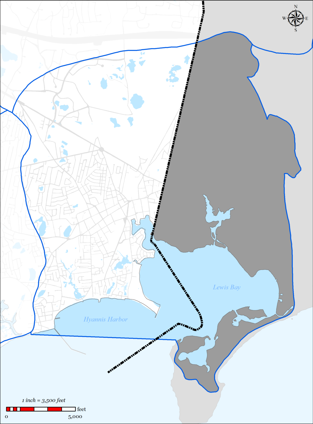
The Lewis Bay Embayment System is a complex estuary located in the Towns of Barnstable and Yarmouth with a southern shore bounded by Nantucket Sound. It is comprised of several primary segments that include Hyannis Inner Harbor, Mill Creek, Snow’s Creek and Stewart’s Creek. For a detailed description of the embayment system, refer to the 2006 MEP Report for the Lewis Bay Embayment (Appendix AA).
The Lewis Bay Watershed is the contributing area for the Lewis Bay Embayment System. The Lewis Bay Watershed is also located between the Towns of Barnstable and Yarmouth (see Figure 5-2). Within the watershed there are 71 identified surface waters including 8 named freshwater ponds and 6 significant freshwater stream outlets (Halls Creek, Stewarts Creek, Snow’s Creek, Hospital Bog, Mill Pond and Chase Brook). Halls Creek Watershed is discussed separately in Section 5.2.2. There are 22 public drinking water wells located within the watershed, 10 of which are located in Barnstable (8 operated by Hyannis Water District, 2 operated by Barnstable Water District.) The Town of Barnstable Water Pollution Control Facility (BWPCF) is located within the watershed. Additionally, the BWPCF treats and discharges wastewater from portions of Hyannis Village and Barnstable Village. The BWPCF is permitted for maximum daily flow treatment of 4.2 MGD and disposal of 2.7 MGD and an annual mass nitrogen load limit of 49,315 pounds per year.
5.2.1.1 SUMMARY OF NEEDS
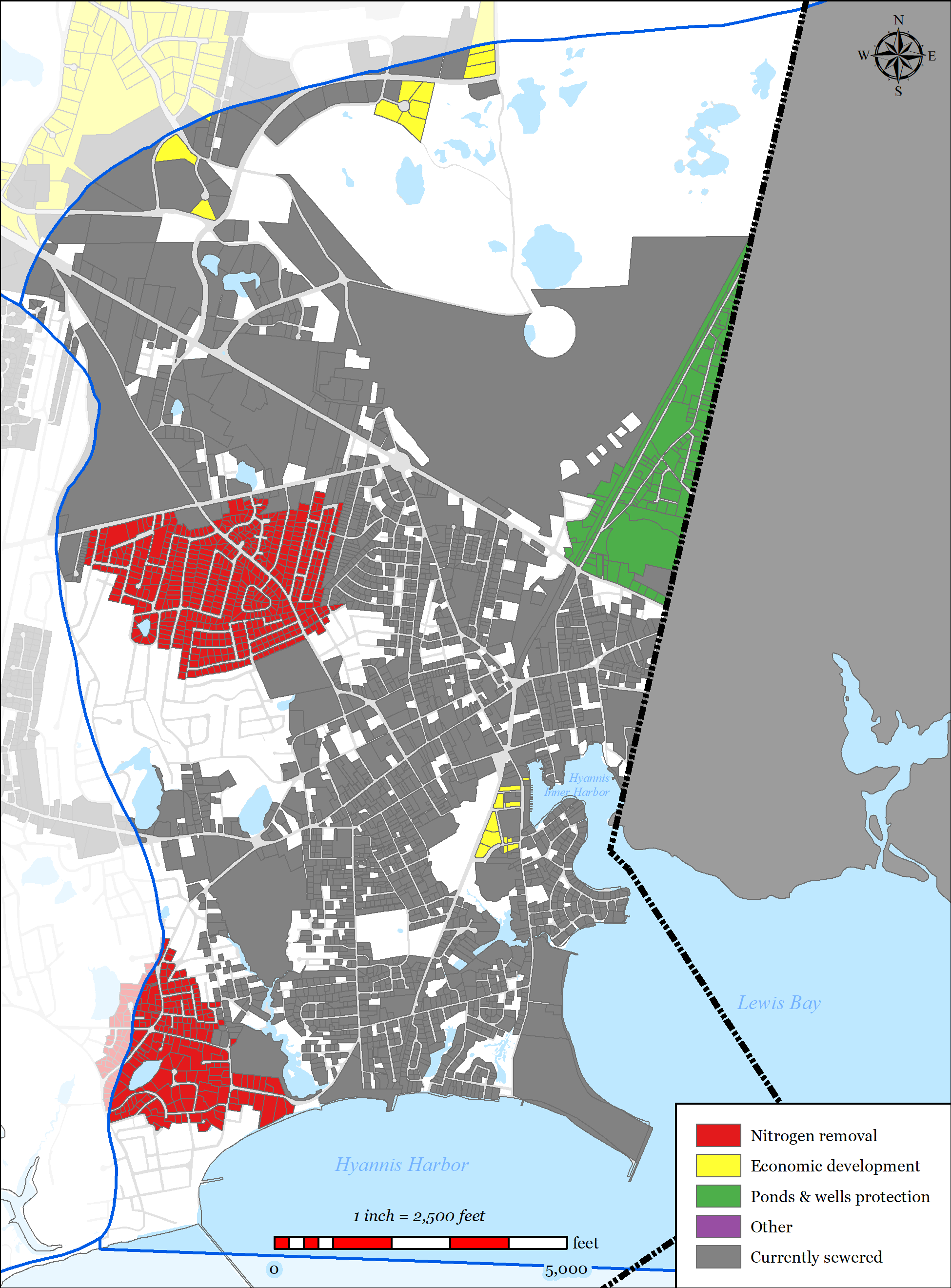
The Town of Barnstable’s wastewater plan has been designed to address multiple needs areas within the Lewis Bay Watershed, including nutrient removal, pond protection, water supply protection, flood zone considerations, and economic development, via sewer expansion within the Lewis Bay Watershed.
-
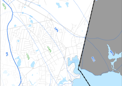
Figure 5-3: MEP-modeled Existing Septic Load Removal in Lewis Bay Watershed
-
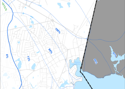
Figure 5-4: MEP-modeled Future Septic Load Removal in Lewis Bay Watershed
-

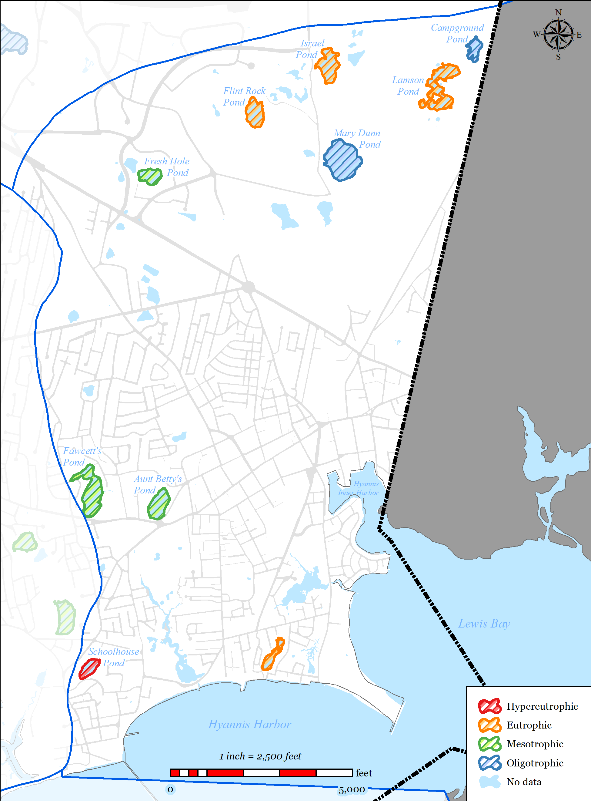
Figure 5-5: Impaired Ponds in Lewis Bay Watershed
-

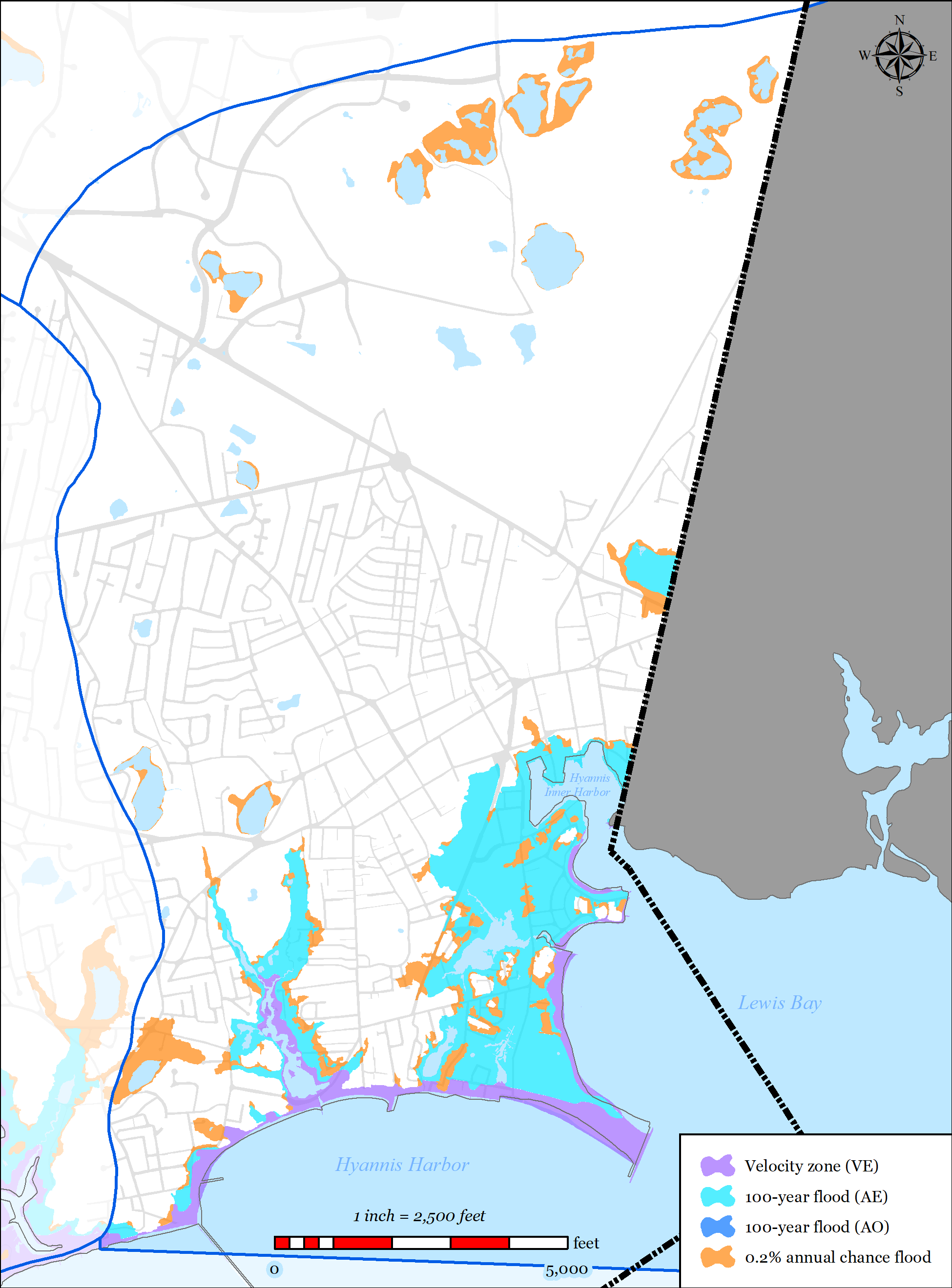
Figure 5-6: FEMA Flood Zones (2014) in Lewis Bay Watershed
-
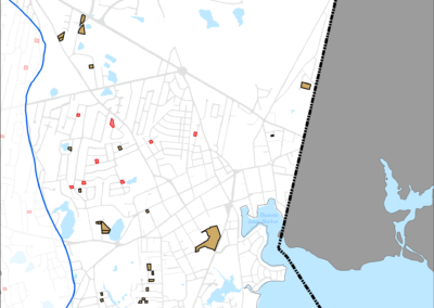
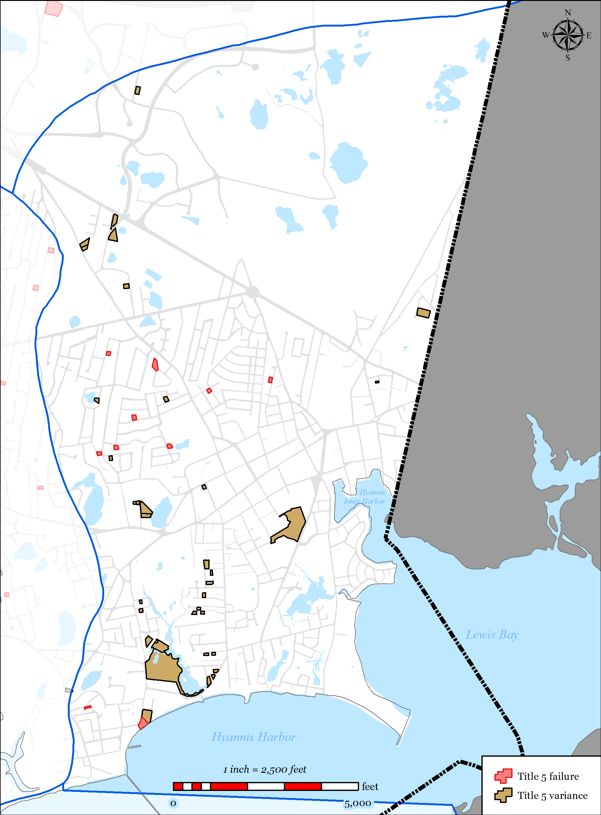
Figure 5-7: Parcels with Title 5 Septic Failures and Variances in Lewis Bay Watershed
-
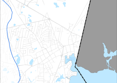
Figure 5-8: Parcels with I/A Septic Systems in Lewis Bay Watershed
-
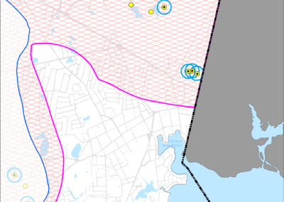
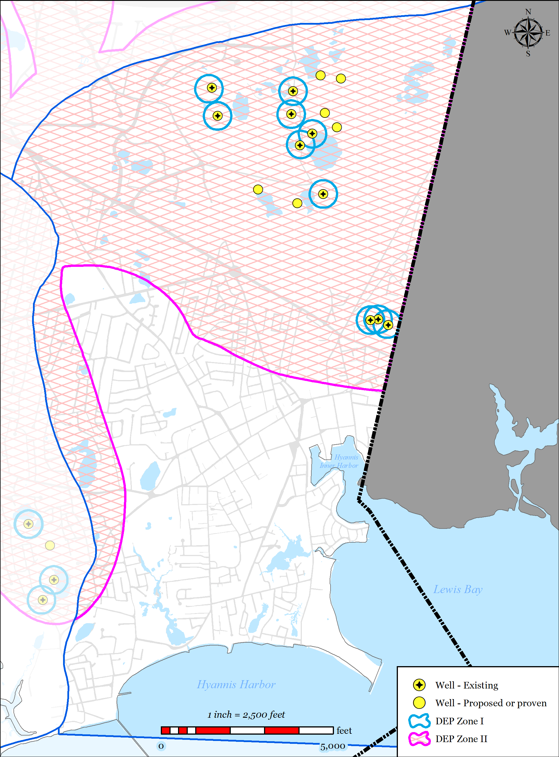
Figure 5-9: Public Water Supply Wells in Lewis Bay Watershed
-
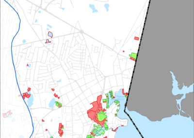
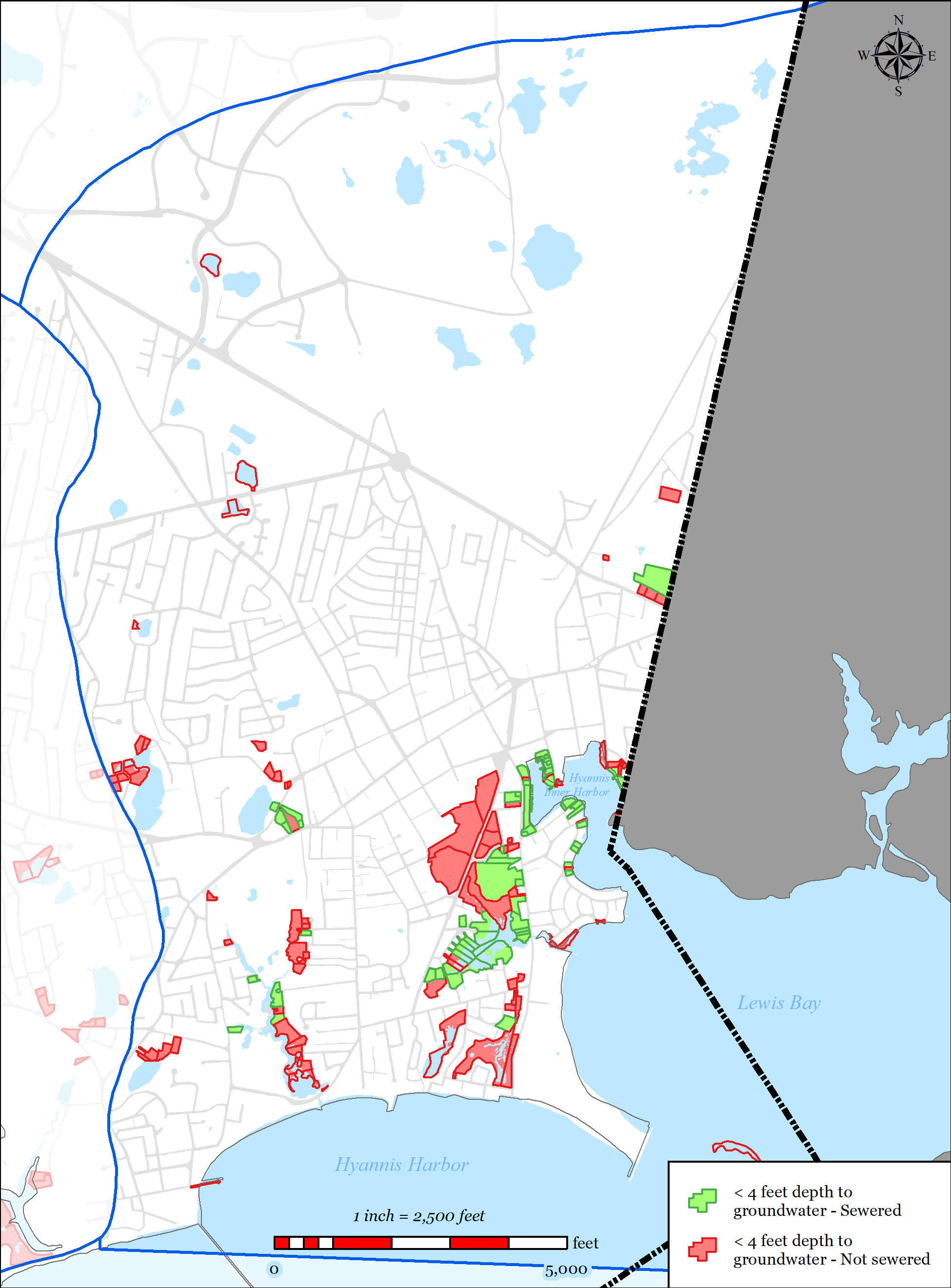
Figure 5-10: Parcels with Less than 4 feet Depth to Groundwater in Lewis Bay Watershed
-
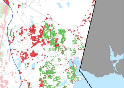
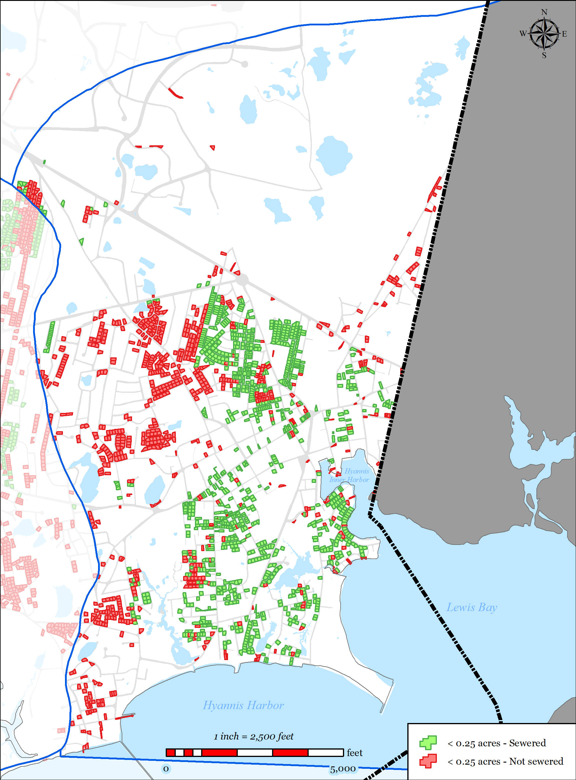
Figure 5-11: Parcels with Less than 0.25 acres in Lewis Bay Watershed
-
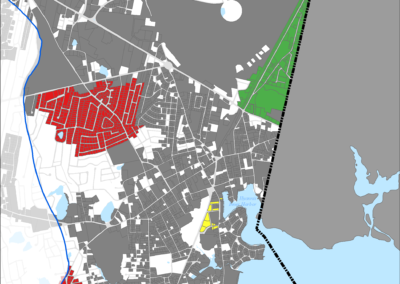
Figure 5-12: Needs Areas in Lewis Bay Watershed
-
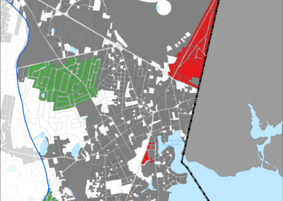
Figure 5-13: Sewer Expansion Plan in Lewis Bay Watershed


5.2.1.1.1 Nutrient Removal
The 2008 MEP technical report for Lewis Bay indicates that the Lewis Bay system exceeds its critical threshold for nitrogen, resulting in impaired water quality. Based upon the findings of the MEP technical report, a TMDL for nitrogen has been developed and approved.
Barnstable has already taken significant action to address nitrogen removal within the watershed via the Stewart’s Creek Sewer Expansion project (refer to Section 2.3.3.1) which connected 288 of residences to municipal sewer, resulting in a reduction of approximately 1.4 kg/day-N of un- attenuated septic load.
The Town’s wastewater plan has been designed to exceed the existing septic load removals suggested in the 2008 MEP Report’s threshold loading scenarios using traditional sewers. The Town also intends to pursue the feasibility in reducing nitrogen concentrations in the effluent of BWPCF by constructing denitrification filters.
The Town retained SMAST to re-model the watershed under a scenario that combines the proposed Town of Barnstable and Town of Yarmouth’s wastewater plans to confirm that the TMDL will be met by the implementation of the two community’s plans. The updated SMAST model which indicates that the TMDL will be met under this scenario (refer to Appendix OO). The Town of Barnstable anticipates that the two communities will pursue a watershed permit for the Lewis Bay Watershed.
5.2.1.1.2 Wastewater Needs (Other Needs)
Title 5 Issues
Integral to the planning process was the Town’s development of a wastewater planning GIS tool which allowed Town staff to spatially map traditional Title 5 concerns such as small lot size, depth to groundwater, existing septic variances, existing known failed septic systems, and systems within Zone IIs. Parcels with area less than 0.25 acres were flagged because they were considered difficult to site a traditional septic system, likely to need septic variances, and increased density leading to increased nutrient loading. Parcels with an average depth of groundwater of less than four feet were flagged as likely to require raised systems which are costly and less desirable for community aesthetics. Existing septic variances and existing known failed septic systems were also mapped.
The tool allows the Town to overlay these layers to identify the “hot-spots” for traditional Title 5 concerns. These areas were then incorporated into the plan where practical. Many of these “hot- spots” overlaid other needs such as nutrients and pond protection. The Plan for the Lewis Bay
Town of Barnstable 5-7 Comprehensive Wastewater Management Plan
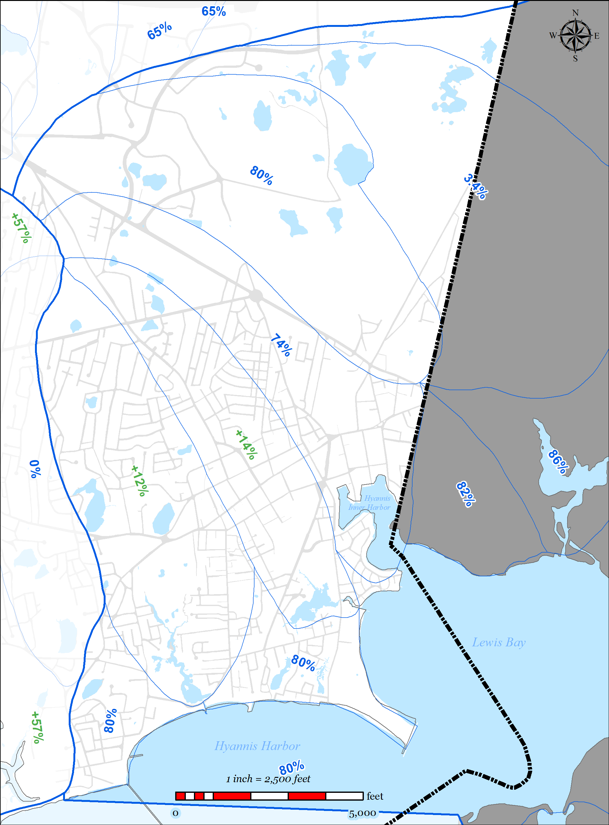
Watershed significantly address traditional Title 5 concerns as shown in the data presented below which was calculated using the Town’s wastewater planning GIS tool (this data does not account for attenuated nitrogen data):
- Total parcels within the Town of Barnstable within the Lewis Bay Watershed = 5,220
- Total parcels connected to existing municipal sewer = 2,256 (43%)
- Parcels with total area less than 0.25 acres = 2,315 (44%)
o 1,119 (48%) already served by municipal sewer
o 329 (14%) additional to be addressed with a traditional solution in the Plan o Total = 1,448 (62%)
Parcels with average depth to groundwater less than four feet = 158 (3%)
o 59 (37%) already served by municipal sewer
o 20 (13%) additional to be addressed with a traditional solution in the Plan o Total = 79 (50%)
Parcels with septic system variances = 27 (0.5%)
o 3 (11%) will be addressed with a traditional solution in the Plan
Parcels with known failed septic systems = 4 (0.08%)
o 1 (25%) will be addressed with a traditional solution in the Plan
Parcels located within a Zone II = 2,498 (48%)
o 842 (34%) already served by municipal sewer
o 265 (11%) additional to be addressed with a traditional solution in the Plan o Total = 1,107 (44%)
Please note that Hall’s Creek Watershed is not included in this data. Refer to Section 5.2.2 for Hall’s Creek Watershed data.
Flood Zones
The majority of the parcels within flood zones in the Lewis Bay Watershed in the Town of Barnstable are already served by municipal sewer.
- Total parcels within the Lewis Bay Watershed = 5,220
- Parcels within FEMA mapped 100-year flood zone (AE/AO) or velocity zone (VE) =601
430 (71%) already served by municipal sewer
23 (4%) that will be addressed with a traditional solution in the Plan Total = 453 (75%)
5.2.1.1.3 Drinking Water Supply Protection and Contaminants of Emerging Concern (CEC’s)
The Hyannis Water System (HWS) supplies drinking water to the majority of the parcels within the Lewis Bay Watershed. In recent years, the HWS has had significant issues with CEC’s, specifically PFOS and 1,4-dioxane. The Town has been proactive in addressing this issue by investing significant capital to update treatment facilities for the HWS, specifically at the Mary Dunn Wells (activated carbon filters) and the Maher Wells (construction of $12 million treatment plant to treat for PFOS, 1,4 dioxane, iron, and manganese).
The Plan continues the effort of protection of the drinking waters source. The sewer expansion will connect 265 properties that are located within delineated Zone IIs to municipal sewer. Of particular concern is the “Old Yarmouth Road” project area which is directly adjacent to and up- gradient from the Maher wellfield. The existing land use within this area is predominantly commercial. The majority of the commercial uses are motor vehicle dealerships and repair facilities which are land uses susceptible to hazardous material release. The proposed Old Yarmouth Road Sewer Expansion project will connect the 131 properties within the project area to municipal sewer, thus reducing the risk of contamination from the commercial uses existing in this area.
5.2.1.1.4 Pond Protection
The Town’s wastewater planning has included detailed studies of ponds 3 acres or larger throughout the Town. Through those studies, there is extensive water data for 9 ponds in the Lewis Bay Watershed. Pond classification of these ponds is shown in Table 5-4 and Table 5-5.
Table 5-4: Lewis Bay Watershed Pond Classification 2009
|
Ultra-Shallow 0 to 2.1m |
Shallow 2.1 to 8.6m |
Deep >8.6 |
|
|
Oligotrophic |
Mary Dunn Pond Campground Pond |
||
|
Mesotrophic |
Aunt Betty’s Pond Fawcett’s |
||
|
Eutrophic |
|||
|
Hypereutrophic |
School House |
Table 5-5: Lewis Bay Watershed Pond Classification 2017
|
Ultra-Shallow 0 to 2.1m |
Shallow 2.1 to 8.6m |
Deep >8.6 |
|
|
Oligotrophic |
|||
|
Mesotrophic |
Fawcett’s Pond |
||
|
Eutrophic |
Lamson Pond Israels Pond Flintrock Pond Fresh Hole Pond |
||
|
Hypereutrophic |
Five ponds within the watershed have been identified as impaired; Lamson Pond, Israels Pond, Fresh Hole Pond, Flintrock Pond, and Schoolhouse Pond. Sewer expansion adjacent to the following ponds for protection from nutrients from septic systems has been proposed.
5.2.1.1.5 Economic Development
The Town’s Planning and Development Department (P&D) identified a number of areas within the Lewis Bay Watershed as needs areas for sewer expansion to promote economic development. These areas include:
- The “Old Yarmouth Road Sewer Expansion” project area located north of Route 28, east of Yarmouth Road and west of the Town Line.
- Parcels not served by municipal sewer in the area of Hyannis Harbor.
- Properties in the “Independence Park” area that have not been connected to municipalsewer to date or have not been developed to date.
5.2.1.2 PROPOSED SOLUTIONS
The plan addresses the needs areas using the following techniques:
Sewer Expansion
o 2,256 of the 5,220 parcels (43%) in the watershed within the Town of Barnstable
are already connected to municipal sewer.
o 241 parcels (5%) in the watershed within the Town of Barnstable were included in the Stewart’s Creek Sewer Expansion Project (1.4 kg/day–N, un-attenuated).
o 840 parcels (16%) in the watershed are included in the proposed sewer expansion plan (14.4 kg/day-N, un-attenuated).
o Total proposed removal of (15.8 kg/day-N, un-attenuated, from watershed within the Town of Barnstable from proposed sewer expansion (including Stewart’s Creek Sewer Expansion Project).
BWPCF Upgrades
Evaluate, design and construct denitrification upgrades to decrease BWPCF total nitrogen (TN) from an existing average of 6 mg/L to a proposed average of 3 mg/L or lower.
- At the BWPCF existing annual average daily flow of 1.67 MGD, 37.9 kg/day-N is discharge to the watershed.
- A 50% reduction in the average effluent discharge TN concentration would remove 18.9 kg/day-N of existing (un-attenuated) nitrogen load from the watershed (approximately 35% of the total attenuated load to be removed per the Cape Cod Commission 208 Watershed Report).
o Seek effluent discharge sites to accommodate additional flow being generated by the sewer expansion connections being treated at BWPCF.
Stormwater upgrades
o The Town’s MS4 program will identify and provide solutions to existing stormwater outfalls.
59 of the Town’s 207 identified stormwater outfalls are located in the
Lewis Bay Watershed.
o The Town’s Public Road program invests on average $750,000 a year in stormwater improvements in the Town’s public roads. These improvements generally include replacement of failed catch basins and leaching structures.
- Fertilizer Regulation
o In 2014 the Town adopted a Fertilizer Nitrogen and Phosphorus ControlRegulation (see Appendix PP). The regulation includes the following:- Provides Best Management Practices and performance standards fornoncertified fertilizer applicators.
- Outlines education, certification, enforcement and penalties.
- Watershed Permit
Work with the Town of Yarmouth to seek a Watershed Permit for the Lewis Bay Watershed
5.2.1.3 FUTURE CONDITIONS
The plan accommodates future growth conditions as follows:
- Watershed is already densely developed.
- Hyannis Village is the main commercial center for Cape Cod. A Growth Incentive Zone(GIZ) has been established within Downtown Hyannis to promote re-development within the area.o The GIZ has existing sewer infrastructure, much of which dates back to the 1930s.
- Studies are on-going (South Street, Barnstable Road, SewerCAD, etc.) to study the existing sewer collection system and determine where upgrades may be necessary to accommodate projected development within the GIZ.
- Projects such as the Infiltration and Inflow Evaluation, Sewer System Evaluation Survey, and Pleasant Street Re-Lining project have addressed the aging infrastructure.
- Projected growth within the watershed is anticipated in areas that are either already served by municipal sewer or are included in the sewer expansion plan.
o The sewer expansion plan has been designed to remove septic load than above and beyond what modeling required for existing conditions in order to accommodate projected growth within the watershed.
o Sewer expansion projects will be designed to accommodate growth within the expansion areas (increased pipe sizes, appropriate pump station sizing, etc.).
Adaptive management and monitoring
o The Town will continue to monitor the embayment, review the Plan and provide formal updates as required.
o Refer to Section 6.4 for the Adaptive Management Plan and Section 6.3 for the Monitoring Plan.